Fiery Heart of St. Augustine Volcano
Science and History of St. Augustine Volcano in the Aluetian Volcanic Arc
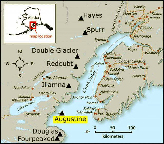
This striking volcano, standing at 4,134 feet tall, is among the most active in the area. It sits atop its own island, spanning five miles in diameter within Cook Inlet. Located approximately 70 miles west of Homer and 170 miles southwest of Anchorage, it has erupted nine times since the 1930s, with the most recent activity occurring between 2005 and 2006. These eruptions included multiple explosions and a significant lava flow down its northern slope.

In addition to its volcanic activity, Augustine has a historical record of triggering tsunamis, which have impacted villages along Kachemak Bay in the past and pose a potential threat to the Homer Spit. To mitigate these risks, scientists continuously monitor both the volcano and the seabed using sensors. Furthermore, sirens are positioned strategically to provide ample warning in the event of an eruption or tsunami, enabling residents to evacuate promptly to higher ground.
The most recent occurrence of structural collapse happened during the largest known eruption of St. Augustine in 1883. Following this event, the growth of new dome formations has restored the volcano to a similar height as it stood before the 1883 eruption. The oldest volcanic rocks on St. Augustine have been dated to over 40,000 years old. Over the past 1800 to 2000 years, there have been at least 11 significant debris avalanches that have reached the ocean, along with the eruption of five major pumice-rich deposits.
Historically, eruptions of St. Augustine have typically involved explosive activity, resulting in the deposition of pumice-rich pyroclastic flows, followed by the extrusion of lava domes accompanied by block-and-ash flows. Situated within the Aleutian volcanic arc, St. Augustine comprises several lava domes and steep, short lava flows. The presence of debris avalanches surrounding the volcano indicates repeated collapses of its central domes, with many extending into offshore areas. These avalanches pose a risk of generating tsunamis, as demonstrated during the 1883 eruption, which generated a tsunami with a height of 30 feet (9 meters) at Port Graham.
Historical records document eruptions of St. Augustine in 1812, 1883, 1935, 1963-64, 1976, and 1986. These eruptions are characterized by their highly explosive nature, often dispersing ash across the Cook Inlet region. Typically, these eruptions conclude with the extrusion of a lava dome, which is less explosive compared to earlier stages of the eruption.
Photos courtesy of Smithsonian Institute, Earth Magazine, Semantic Scholar, and Earth.com.


